


Description
HTC AL-7010 Multifunction Digital Altimeter — Your All-In-One Outdoor Navigation & Environmental Companion
The HTC AL-7010 is a robust, multifunctional tool that brings together altimeter, barometer, thermometer, hygrometer, compass, clock, calendar and more in a single portable unit. Designed for adventurers, pilots, hikers, climbers, wilderness travelers, and anyone who demands accurate environmental data on the go, the AL-7010 combines precision, durability, and intuitive usability.
Core Capabilities and Measurement Features
Altimeter Mode
-
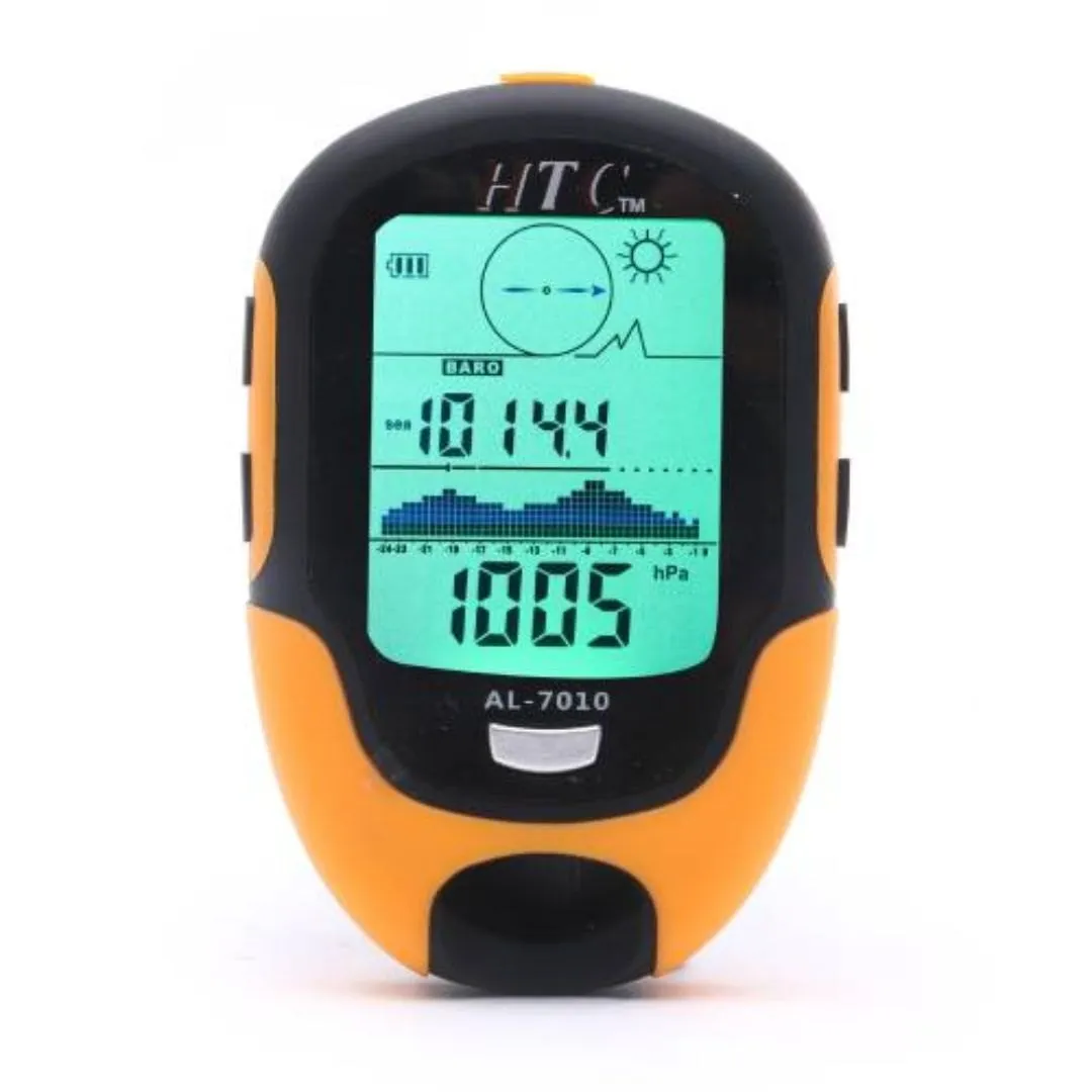
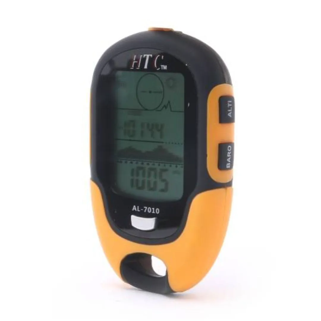
Altitude Range: From approximately −700 meters to 9,000 meters (or −2,296 to about 29,500 feet), the device tracks above sea level elevation with wide coverage for mountain climbing or aviation.
-
Resolution: 1 meter (or 1 foot), allowing fine-grained elevation tracking with minimal jumps between readings.
-
Max / Min Memory: Stores both maximum and minimum altitude values during a session, enabling you to assess ascent/descent peaks easily.
-
Altitude History & Graphical Display: Maintains a log of altitude over a 12-hour period, with graphical trends. This chart lets you see climbs, drops, plateaus—valuable for pacing, acclimatization, or safety monitoring.
-
Total Altitude Gain / Loss: Keeps track of cumulative elevation changes (total climb and descent), giving you meaningful metrics over the day’s journey.
Barometer & Weather Forecasting
-
Pressure Range: 300 to 1,100 hPa (hectopascals) or millibar equivalents, roughly 8.84 to 32.44 inHg.
-
Resolution / Accuracy: Approximately 1 hPa (or mbar) or 0.01 inHg for precision.
-
Barometer Memory / Max-Min: Keeps maximum and minimum pressure readings, plus houses historical pressure readings over time, forming a basis for weather prediction.
-
Pressure Trend Graph & Icons: Displays 12-hour pressure history as a chart, along with trend arrows and weather forecast icons (Sunny, Slightly Cloudy, Cloudy, Rain, etc.), letting you anticipate changing conditions before they arrive.
Temperature & Humidity Monitoring
-
Temperature Range: From about −20 °C to +60 °C (about −4 °F to 140 °F), making it usable from cold weather to warm environments.
-
Temp Resolution / Accuracy: Roughly 0.1 °C (or about 0.18 °F), offering fine gradations in environmental monitoring.
-
Humidity Range and Accuracy: From 20% to ~95% RH, with around ±1% RH accuracy, providing useful readings for comfort, safety, or weather forecasting reliance.
-
Max / Min Memory: Tracks max and min temperature and humidity over the session. Useful for knowing peak environmental conditions, especially when you’re exposed during travel or in shelters.
Compass, Clock & Time-Keeping Features
-
Compass Mode: Included for directional guidance. Calibration and magnetic declination settings are available to ensure compass accuracy.
-
Clock / Perpetual Calendar: Real-time clock with hours, minutes, seconds; a perpetual calendar function displays day, month, year with automatic date rollover; alarm clock support for daily alarms. 12-hour or 24-hour formats selectable.
Additional Functions
-
Stopwatch: Measures up to 9 hours, 59 minutes, 59 seconds, with 1/10th second or 1 second resolution depending on mode. Great for timing hikes, rest periods, or events.
-
Low Battery Indicator: Alerts you when battery is running low so you can plan replacements before the device fails unexpectedly.
Design, Build & Physical Details
Housing & Dimensions
-
Size: Approximately 177 mm (H) × 98 mm (W) × 39 mm (D). This shape is easy to hold or carry with one hand, pockets, or pack.
-
Alternative Smaller Version: There are versions with compact size, e.g., 100 × 66 × 20 mm, and weight around 90 g, for users who desire portability.
Battery / Power & Battery Life
While the manual indicates battery charger is included and built-in power management functions like low-battery indication, exact battery type or backup is specified. The unit includes standard accessories and comes ready with belt or strap attachments.
Durability & Environment
-
Operating Temperature: Approximately −10 °C to +60 °C under usage; storage conditions somewhat broader (from −30 °C up to +65 °C) without damage.
-
Humidity Tolerance: Up to ~90% RH (relative humidity), non-condensing, to handle moist or rainy conditions.
Usability & Interface
Controls & Modes
-
The front panel includes multiple buttons: mode switching (Altimeter, Barometer, Thermometer, Hygrometer, Compass), setting functions, history review, light/backlight controls.
-
Graphical screens: Trend graphs for altitude and pressure over time; max/min memory screens; total altitude gain and loss display; time/date/alarm/calendar screens.
Units & Localization
-
Metric / Imperial: Units for altitude (meters / feet), pressure (hPa / inHg), temperature (°C / °F) are selectable.
-
Time Format: 12/24-hour selectable format. Calender includes day of week.
Display & Alerts
-
Backlight / flashlight functionality built in—helps in dark conditions.
-
Trend arrows or indicators—for pressure or altitude changes—help user see whether conditions are stable or changing.
Practical Applications & Use-Cases
The HTC AL-7010 is especially useful in scenarios such as:
-
Mountaineering and Hiking: Monitor elevation gain/loss; track altitude profile; glance at pressure trends to anticipate weather; use compass for direction; timing rest or segments.
-
Aviation & Paragliding: Useful altimeter range; can track altitude above sea level; may serve for recreational aviation or ultralight aircraft, though not certified professional gear.
-
Outdoor Adventure & Travel: Backpacking, trekking, camping or navigation; tool can help with weather forecasts in remote areas, knowing peak altitudes and tracking cumulative gains.
-
Scientific Field Work: Environmental students measuring temperature/humidity; geomorphology or geology or forest canopy studies needing barometric pressure; altitudinal species distributions.
-
Training & Fitness: Tracking elevation gain during trail running, biking using stopwatch and cumulative gain/loss can help measure workout intensity.
-
Everyday Use & Weather Watching: As a household or casual user, it offers weather forecasts based on pressure, time & date functions, alarm, etc.; useful for gardeners, campers.
Comparison / Why AL-7010 Over Basic Altimeters
-
AL-7010 doesn’t just give raw elevation—it adds History, Graphical Displays, Barometric Trends, Weather Forecasting, Max/Min memory for multiple parameters, and multiple sensors (temp/humidity/compass). Many basic altimeters do only elevation reading.
-
Unit Flexibility: Ability to switch units (metric/imperial), change scale, time formats etc., offers user comfort and global usability.
-
Memory & Tracking: The ability to see previous trend (12 hour altitude, pressure) is valuable for safety and planning.
-
Multiple Functionality: Inclusion of compass mode adds direction; temperature and humidity add environment awareness.
Full Spec Summary Table
| Parameter | Specification |
|---|---|
| Altitude Range | −700 m to 9,000 m (≈ −2,296 ft to ~29,500 ft) |
| Altitude Resolution | 1 meter / 1 foot |
| Barometer Pressure Range | 300 to 1,100 hPa (≈ 8.84 to 32.44 inHg) |
| Pressure Resolution | 1 hPa or mbar / 0.01 inHg |
| Temperature Range | −20 °C to +60 °C (−4 °F to 140 °F) |
| Temperature Resolution | 0.1 °C / ~0.18 °F |
| Humidity Range | 20% to ~95% RH (relative humidity) |
| Humidity Accuracy / Resolution | ±1% RH |
| Stopwatch Duration & Accuracy | Up to 9:59:59; resolution 0.1 second / second |
| Memory Functions | Max/Min altitude; altitude history (12 hours); pressure history; temp/humidity history |
| Weather Forecasting | Icons (Sunny, Cloudy, Rain etc.); Trend Indicators |
| Compass | Digital compass mode; calibration; declination setting |
| Units | Metric / Imperial (m/ft, hPa/inHg, °C/°F) |
| Time & Calendar | 12/24-hour mode; Perpetual calendar; day/month/year; alarm clock |
| Display / Interface | Graphs, trend charts; buttons for modes; backlight / flashlight |
| Dimensions | Around 177 × 98 × 39 mm for larger model; some compact versions ~100 × 66 × 20 mm |
| Environmental Tolerance | Operating −10 to +60 °C; storage −30 to +65 °C; humidity up to ~90% RH |
| Power / Battery | Includes battery charger or power supply; low battery indication |
| Accessories | Handy belt, manual, strap or belt hook; generally complete set |
Practical Tips & Best Practices
-
Calibrate Sea-Level Altitude: In altitude mode you can set sea-level altitude for accurate readings, especially when elevation zero reference matters (e.g. in field or walking up mountain).
-
Monitor Pressure Trends: Sudden drops can indicate approaching bad weather; the built-in forecast helps, but always carry backup tools for safety.
-
Use Max/Min History: When climbing or descending, switch to max/min to verify peaks without constantly watching the device.
-
Compass Calibration: Should be done when first used or after battery change to correct for magnetic interference. Hold level and rotate as per manual.
-
Protect from Wet Conditions: Device is water-resistant but not waterproof; avoid submerging. Keep gasket for battery properly seated.
Summary & Why Choose AL-7010
The HTC AL-7010 Multifunction Digital Altimeter is more than just an elevation meter—it’s an environment-aware, multi-sensor device built for those who demand accurate altitude, pressure, direction, and climate info in one package. With features such as:
-
Wide and high-resolution altimeter range
-
Barometer history and weather forecast
-
Temperature and humidity tracking with memory
-
Compass with calibration options
-
Time, calendar, stopwatch, alarms
-
Graphical trend displays
-
Unit flexibility and ease of use
…it stands out as a comprehensive tool for a variety of users: outdoors, adventure, safety, training, scientific research, and casual environmental awareness.

Reviews
There are no reviews yet.